 |
Satellite
Contact Report Analysis & Prediction
SCRAP
Bytheway
Software Development Lab (BSDL) |
 |
|
Introduction to Scrap
Satellite Contact Report Analysis &
Prediction (SCRAP) is a tracking, report, analysis,
prediction and 3-D real time display program. It tracks
and predicts passes of satellites based on the
geographical location of the ground station, the current
date and time and Keplerian orbital data for the
satellites of interest to the ground station.
The minimum
recommended platform is Windows 98 or better running a
Pentium Processor 500 MHz or greater, 256 Mbytes RAM and a
graphics accelerator card with OpenGL support. Of course it
helps to have at least 1024x768 resolution. SCRAP has
been recently updated to give it better performance and
added features. |
|
SCRAP
can track thousands of satellites and performs contact reporting, analysis and prediction. SCRAP
was first featured in the
AMSAT Journal
Nov-Dec 2003 and again in
Jan-Feb 2006 .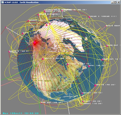
In addition to the satellites, it
provides ground labeling for over 260 countries and 2265
cities. The user is able to pick from up to 27 different map
textures, and apply islands, lakes, rivers, US states,
coastal lines and national boundaries lines.
SCRAP Support -
When the software is updated, your old PASS KEY
will still work. Software
updates (fixes) and frequently asked questions can be found
on the support page. |
|
Introduction to Scrap's Features
1080p High Definition View is
available by making full screen |
|
Demonstration of ISS Satellite
Contact
1080p High Definition View is
available by making full screen |
|
Step 1:
Download the software and install it on your
computer. Initially it functions in the TRIAL
mode. Everything will work with the exception that you will not be able
to download recent Two Line Orbital Elements (TLE).
Currently the license
PASS KEY is only being provided to
federally licensed amateur radio operators for non-commercial personal
use.
The TRIAL
mode gives you the opportunity to check out the product.

|
Step 2:
After you have played with the software and find it suitable for your
needs, you must acquire the PASS KEY
that will unlock the capability to download recent ephemeris data (TLE)
from the internet using the software. Send email to
BSDL.
The subject title of the
email must have the words "Request for SCRAP License"
in the title
Please provide me with adequate
proof that you hold government-issued amateur radio license
or you will not receive the key. An image of your license
will suffice, similar to what Echolink requires for it's
license
|
Step 3:
We receive your email and email you the
PASS KEY which unlocks the software.
I verify to my best ability
that you are a licensed amateur radio operator and that the
end application is not for business or commercial use.
|
The display is organized into tabbed
accessible panels, thus allowing the user to control SCRAP’s features.
The following descriptions will provide more details for each of the
satellite analysis panels. In summary these functions are:
| Initialize |
Allows the user to load in the various TLE
files, and to download new TLE files from the
Internet |
| Earth View |
Selection of viewpoint to include country,
satellite, QTH, etc. and to select the Earth
Orthographic projection overlay map, and display
options |
| Target QTH |
Select the QTH to be used for pass
predictions and reports |
| Sim Time |
Define a simulation and step time other than
current UST time. |
| Ephemeris |
Set the SGP propagation model and view the
position and velocity of satellites |
| TLE Editor |
View and edit the decoded TLE parameter in
classic Orbital Elements. |
|
| Pass Reports |
Produce predicted orbit pass reports, visible
passes and solar illuminations. |
| APRS |
Download APRS stations via Internet.
Locations can be used for prediction and display. |
| Multi Track |
Display current and upcoming passes in real
time |
| Antenna |
Az/El rotor control for up to four rotators. |
| Conjunctions |
Calculate conjunctions between satellites |
| RFI |
Calculate radio frequency interference for
satellites in contact |
| Astrodynamics |
Calculate position of the planets. |
|
|
Supported Computer
Platforms
SCRAP is not for the underpowered computer. In order to
propagate ephemeris for each of the satellites it
displays and reports on, it performs millions of
floating-point calculations every second. Therefore, the
minimum recommended platform is Windows 98 or better
running a Pentium Processor 500 MHz or greater, 256
Mbytes RAM and a graphics accelerator card with OpenGL
support. Of course it helps to have at least 1024x768
resolution.
For example, test results on a Windows 98 500 MHZ Pentium
shows that it takes about 5 seconds to calculate 200
satellite vehicle positions and display the results. |
Installation Instructions
SCRAP is distributed using the
Windows installer software (.MSI file) and has all of the
directory information and files needed for a basic
startup of the program. To extract the files, download the WinZip
and save it to your computer. Unzip and execute the "Setup.exe"
file. This will create a startup icon on your desktop.
SCRAP does not access the Windows registry except to install and remove
the product or place any
hidden files on your system. It does have TCP/IP code for
downloading TLE and APRS data from the Internet. |
|
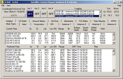
Main
Window and Initialization Page
The main window displays the status of each of the
four antenna controllers, GMT time, QTH ground station,
Sun and Moon positions. There is also a File option and
View option. The View option provides the ability to open
up some of the windows as a separate child popup.
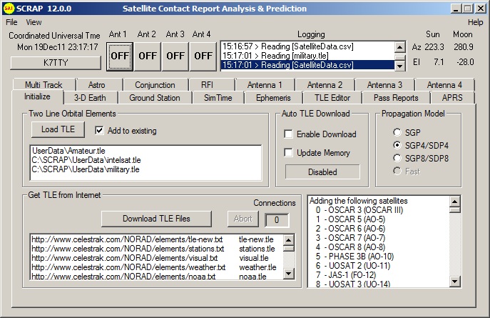
SCRAP opens with an initialization page as shown. The top
left window is used to load Two Line Orbital Element
files into the application. Pressing the “Load
TLE” button brings up a file box allowing you to
load any one of a number of satellite TLE files. Checking
the “Add” button allows you to keep the
existing selection and add additional satellites to the
application.
TLE data is downloaded using a pre-built script file.
Pressing the download button initiates TCP/IP connections
to the TLE source, and in a matter of a minute or so, you have
downloaded the latest files set. |
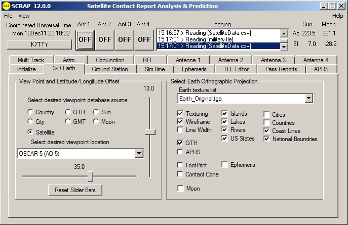 |
Three Dimensional Earth View
From the Earth View panel you can select the Earth
orthographic projection of your choice. Your selection is
then loaded into SCRAP and the Earth is displayed in
it’s own window. On slower computers this may take
several seconds. The check boxes allow you to select
display attributes on the Earth display. The View Point
and Latitude/Longitude Offset allows you to select from a
number of options for choosing your viewpoint. If you
select a satellite, you are positioned above the
satellite and the Earth rotates under your location.
The Earth-Simulation 3-D model displays a selected Earth
map texture overlaid on the globe. You can rotate the
Earth, zoom-in, etc. using the mouse and control key. Map
textures of the Earth can be changed at any time during
the run. |
|
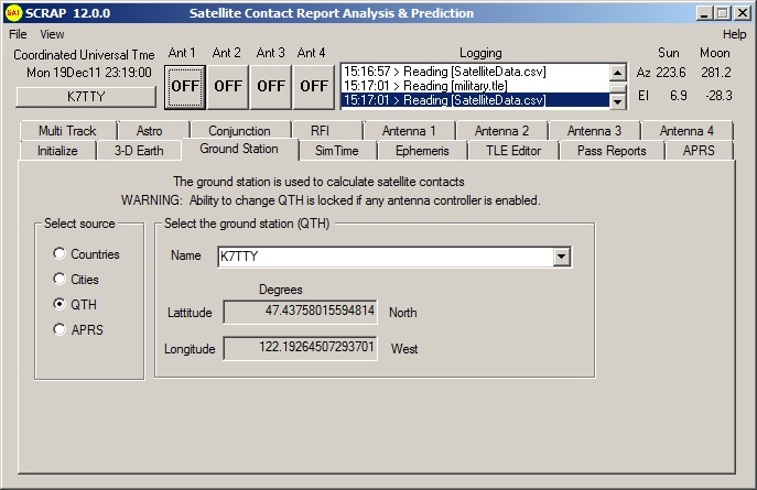
Ground Station QTH
The original PREDICT tool performed all of its
predictions based on a user input QTH, I’ve modified
it so that the user can specify multiple QTH locations.
This panel allows you to change the default QTH location
to any city, country or QTH of your choice.
SCRAP added the capability for the user to assign any
country, city, or APRS station to be the new QTH. You can easily move
from location to location to predict and display satellite
contacts for any location.
SCRAP provides ground labeling
for over 260 countries and 2265 Cities. In addition, the
user is able to pick from 27 different map textures, apply
island, lake, rivers, US states, coastal lines and national
boundaries lines..
|
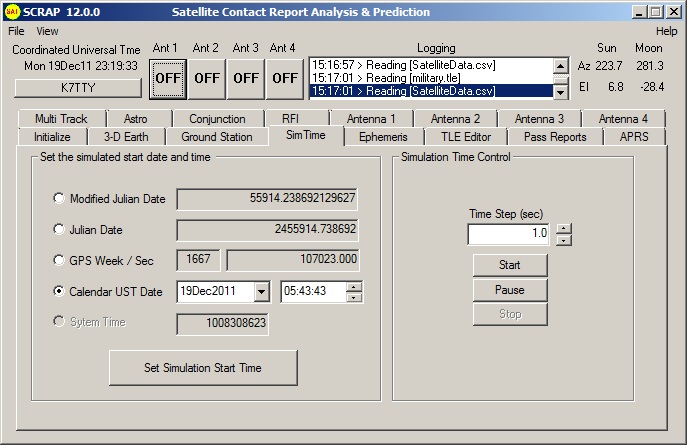 |
Simulated Time
No tracking program is complete unless you can input
any date time condition and set a fast forward or
backwards time step. This panel allows you speed up
reality.
The ability to control simulated time is provided to
allow you to fast forward the simulation to get a
perspective in fast motion of what the satellites are
doing. You can also set a negative step time and run the
simulation in reverse. The various time formats were
provided for flexibility in setting up the simulation.
All displayed times are in UST (GMT), but the user has
the option of specifying times in GPS, MJD, JD or
calendar formats.
All times are in UST (GMT) |
|
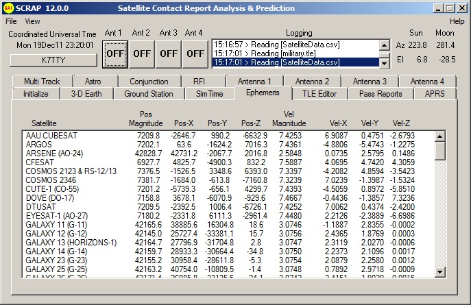
Ephemeris Propagation Model
The main ephemeris engine is Dr. T. Kelso's Pascal's
SGP, SGP4, SGP8, SDP4 and SDP8 satellite ephemeris
propagation routines. These models were borrowed from
SPACETRACK REPORT NO. 3, Models for Propagation of NORAD
Element Sets, Felix R. Hoots, Ronald L. Roehrich,
December 1980.
This panel displays the current ephemeris vector data for
position and velocity. In addition it allows you to
switch ephemeris models in real-time. Normally you should
never have to leave the SGP4/SDP4 model, but it’s
interesting to switch between the other models and
observe the differences. |
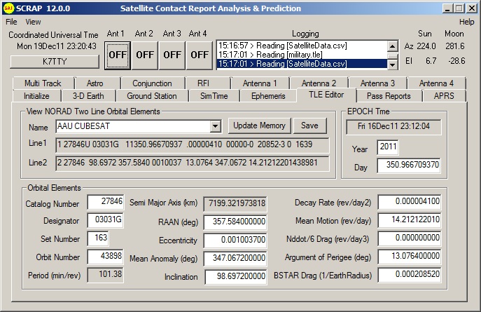 |
TLE Viewer and Editor
This panel provides you with a tool to view and edit the
orbital elements stored within the NASA two line orbital
elements. One of the most important fields on this page
is the EPOCH Time. If your time is stale, then your
vehicle positions will not be accurate.
Data for each satellite
will consist of three lines in the following format:
|
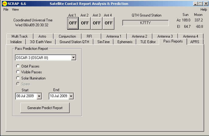 |
Satellite Pass Reports
Satellite contacts in the program’s database are calculated at a
once/second rate. Separate windows are used to display current passes
and upcoming passes. SCRAP also can create text-format reports of
predicted passes.
Tracking data is also displayed for satellites in contact
range. The name, azimuth heading, elevation,
sub-satellite point latitude (in degrees North) and
longitude (in degrees West) positions are provided, along
with the slant range distance between the satellite and
the ground station (in kilometers).
The Visible Passes report option displays the satellites
in sunlight where the ground station is under the cover
of darkness.
Solar illumination prediction report indicates how much
sunlight a particular satellite will receive in a 24-hour
period. |
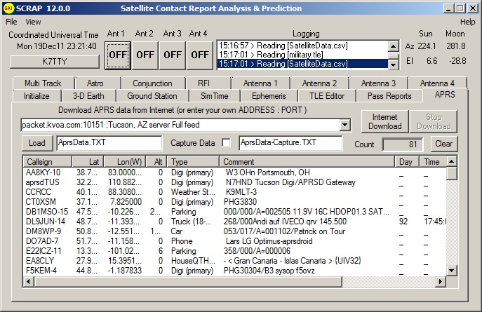 |
Automatic Packet Reporting System
(APRS) The project takes an interesting twist on this
addition. The Automatic Position Reporting System (APRS)
developed by Bob Bruninga, WB4APR, is used for tracking
and digital communications with mobile GPS equipped
stations with two-way radio (ref. http://www.aprs.org).
SCRAP provides an Internet access that downloads APRS
station information residing on multiple WEB servers as
defined by the APRS Protocol published by the Tuscon
Amateur Packet Radio Corporation.
To use the Internet download feature, select the desired
WEB server and press “Internet Download”. If
the counter does not increment, try another server, not
all servers in my current list provide the proper
protocol. Most servers will never disconnect, so the
SCRAP design lets you determine when enough stations have
been added to the list. You can go to multiple servers
and add more stations as desired. |
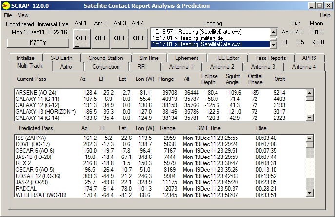 |
Multi-Track
and Predicted Pass Real-Time
The top window shows the current
potential contacts. The bottom display shows the upcoming
contacts. Probably the most useful number on this display
is the time until rise of the next contact. Satellites
are sorted by rise time. |
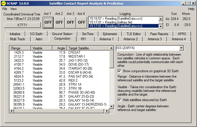 |
Conjunction (Satellite 2 Satellite)
A conjunction between satellites occurs when two
satellites can be seen by each other.
1080p High Definition View is
available by making full screen |
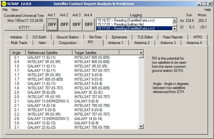 |
Radio Frequency Interference (RFI)
Radio Frequency Interference is possible if two
satellites as viewed from the ground station have a low
delta angle between them. In the case of an omni
directional antenna, it could be possible that two
satellites could be communicated with at the same time. |
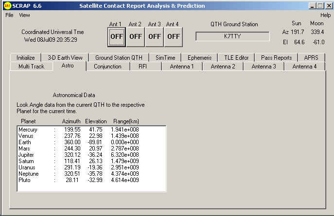 |
Astronomical Calculations (Planets)
Just for fun this page was added using the plan404
ephemeredes developed by Steve Moshier. The planets, sun
and moon are also available within the antenna pointing
page described next. One application is to allow you to
control your antenna for Earth-Moon-Earth comunications
or point solar cells at the sun. |
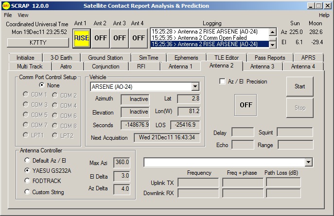 |
Antenna
Rotor Controller
This antenna feature allows the user to control an
azimuth-elevation rotor for a real-time contact for up to 4 simultaneous
contacts.
Rotor control is provided for the Yaesu GS232A, FODTRACK and
the default standard controller interface.
Elevation angles are suppressed until the angle rises
above zero. The QTH is selected from the “Target
QTH” panel, and once you start this display, you
cannot change the QTH until you stop the action.
The precision function allows you to update the rotor
with data less than one degree accuracy. Data is sent to
the rotor once per second.
The Icon will change from an antenna (currently shown),
OFF. FADE, RISE or LOS for loss of signal. The Icon is
also displayed in the upper section. |
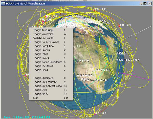 |
Earth Image Control
Use the mouse and it's left-button to rotate earth.
Hold down Ctrl before you hit the left mouse button to
scale the earth. Right-Click the window to get the
options menu. Note that options are controllable by
keyboard too.
It’s been said that SCRAP can handle up to 2000 satellites.
At runtime the default is 500. If you wish to increase the
number then include a command line parameter that defines
the total number you wish to support, i.e. “c:\SCRAP\Scrap.exe
2000” for 2000 satellites. Just remember that the more
satellites you add to the list, the slower the overall
application runs.
| NUM_COUNTRIES |
There are 267 countries included in the
database latitude/longitude. |
| NUM_CITIES |
A total of 2267 cities are included in the
database with latitude/longitude. |
| NUM_QTH |
You can specify up to 50 unique QTH locations
in the user-defined “Scrap.INI” file. |
| NUM_APRS |
For some odd reason, included is space for up
to 30,000 worldwide APRS stations in the dynamic
database. |
|
|